 Subscribe to the Coal Tattoo
Almost level: Study details how mining flattens W.Va.
February 8, 2016 by Ken Ward Jr.
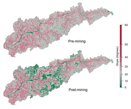
The hillside slope of West Virginia’s Headwaters Twentymile Creek watershed pre- and post-mining, calculated from elevation maps. Photo provided by Duke University.
There’s an important new study out from the folks at Duke University that provides some fascinating new calculations of the impacts of mountaintop removal on West Virginia’s coalfield environment.
Here’s the summary abstract:
Land use impacts are commonly quantified and compared using 2D maps, limiting the scale of their reported impacts to surface area estimates. Yet, nearly all land use involves disturbances below the land surface. Incorporating this third dimension into our estimates of land use impact is especially important when examining the impacts of mining. Mountaintop mining is the most common form of coal mining in the Central Appalachian ecoregion. Previous estimates suggest that active, reclaimed, or abandoned mountaintop mines cover ∼7% of Central Appalachia. While this is double the areal extent of development in the ecoregion (estimated to occupy <3% of the land area), the impacts are far more extensive than areal estimates alone can convey as the impacts of mines extend 10s to 100s of meters below the current land surface. Here, we provide the first estimates for the total volumetric and topographic disturbance associated with mining in an 11 500 km2 region of southern West Virginia. We find that the cutting of ridges and filling of valleys has lowered the median slope of mined landscapes in the region by nearly 10 degrees while increasing their average elevation by 3 m as a result of expansive valley filling. We estimate that in southern West Virginia, more than 6.4km3 of bedrock has been broken apart and deposited into 1544 headwater valley fills. We used NPDES monitoring datatsets available for 91 of these valley fills to explore whether fill characteristics could explain variation in the pH or selenium concentrations reported for streams draining these fills. We found that the volume of overburden in individual valley fills correlates with stream pH and selenium concentration, and suggest that a three-dimensional assessment of mountaintop mining impacts is necessary to predict both the severity and the longevity of the resulting environmental impacts.
In a press release from Duke, lead author Matt Ross said:
There hasn’t been a large-scale assessment of just the simple full topographic impact of mountaintop mining, which occupies more than 10 percent of the land in the region we studied. [We found] the impact is deep and extensive. It is locally large and more wide-ranging than other forms of mining.
Another of the authors, biology professor Emily Bernhardt, explained:
We tend to measure the impact of human activity based on the area it affects on a map, but mountaintop mining is penetrating much more deeply into the earth than other land use in the region like forestry, agriculture or urbanization. The depth of these impacts is changing the way the geology, water, and vegetation interact in fundamental ways that are likely to persist far longer than other forms of land use.
Among the more interesting findings of this study:
Prior to mining, watersheds in the region had a distinct unimodal slope distribution with peak frequencies ∼28°. Mining activities have altered the slope distributions, so that now there are two characteristic peak frequencies occurring at slopes of ∼2° and ∼20°. Such bimodal slope distributions are rarely observed in watersheds of this size in the absence of mining. This change to mined landscapes has created a secondary slope peak for the entire 11 500 km2 region. In mined locations, there has been a 30% increase in areas with slopes lower than 25°, reflecting newly created flat ridges and gentle hill slopes, once rare in Central Appalachia. In many areas, mining also creates flat plateaus, a sharp contrast to the observed pattern of steepening topography in the Appalachians caused by differential erosion.
The study, published in the journal Environmental Science and Technology, is available here (subscription required).
And more from their press release:
Of particular interest to the team is how the conversion from solid bedrock to porous valley fills changes the way water moves through the area, and whether this increases the likelihood that water will pick up alkaline mine pollutants.
“You go from having shallow soil that is between half a meter and two meters deep, to something that is like a soil that is a hundred meters deep. The way the water moves through those two different landscapes is really different,” Ross said. “There are valley fills that are the size of an Olympic swimming pool and then there are valley fills that are 10,000 Olympic swimming pools, so there is a huge range in the capacity they have to hold water.”
Ross says the data from this study indicates a correlation between the total volume of displaced rock and the concentration of certain pollutants, like selenium, downstream.
“We have data that the water quality impacts can last at least 30 years, but the geomorphology impacts might last thousands of years,” said Ross. “Once you have these flat plateaus, it sets up a whole new erosion machine and a whole new way that the landscape will be shaped into the future.”
Bernhardt said the findings should also inform planning in the region. “Even if we stopped mountaintop mining tomorrow, what kind of landscape is going to be left behind, and what are the constraints on what the landscape can be used for?”