 Subscribe to the Coal Tattoo
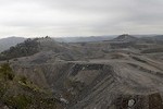
King Coal Highway: If we build it, will jobs come?
November 9, 2012 by Ken Ward Jr.

You remember how just before the election — when residents around our state were worried about the approaching Superstorm Sandy — West Virginia political leaders put out a press release attacking the Obama administration, alleging permit reviews by the U.S. Environmental Protection Agency were holding up a mining project related to the King Coal Highway, and potentially costing the southern coalfields thousands of jobs?
Sen. Joe Manchin was especially upset, saying in the release:
As a West Virginian, I watched this project come together one partnership at a time for the past two decades. As Governor, I made sure that the state supported the project’s permitting and funding requests. Now, as Senator, I am incensed and infuriated that the EPA would intentionally delay the needed permit for a public-private project that would bring so many good jobs and valuable infrastructure to communities that so desperately need them. The EPA has lost court case after court case for its overreach, and it should be using better judgment by now. I vow to work with the Governor’s office, our entire Congressional delegation and members of both parties to make sure that this vital project will move forward.
Rather than fight this project, the EPA should be embracing it as a model of how to work together. We’ll put the land to good use after it has been mined by building the King Coal Highway. We’ll build a wastewater treatment plant that will clean up millions of gallons of water for people in the Pigeon Creek Watershed – eliminating raw sewage and other pollutants. Not only will we be protecting the jobs of the 145 people working at this project, we’ll be putting hundreds more people to work with good-paying jobs. The EPA’s callousness jeopardized the funding for all these projects. In short, this project is a win-win and the EPA is trying to make it a loser.
Let’s ignore for a minute the question of whether it is appropriate for a governor to step in and make sure the state “supported … the permitting” of a particular strip mine. Let’s focus instead on this job business, and look closely at what the congressional delegation’s press release, issued by Sen. Manchin’s office, said about the project related to CONSOL Energy’s Buffalo Mountain permit, on one end of the King Coal Highway project. Here’s the important line:
The Mingo County Redevelopment Authority estimates that 2,000 acres of land could be developed and 2,500 new jobs could be created in the next 15 years.
Sounds pretty great, right? I wanted to know more, so I asked Emily Bittner, Manchin’s media spokeswoman, where exactly Sen. Manchin got those figures. She was kind enough to send me this Mingo County Redevelopment Authority fact sheet, and to highlight what she felt was the relevant portion of it:
The most significant of our post mine land use projects which are currently under construction include a fifteen mile section of the I-73/I-74 King Coal Highway and the Mingo County Air Transportation Park. The completion of these projects in accordance with our LUMP [Land Use Master Plan] will result in a savings to taxpayers of nearly $400 million, the creation of over 2,000 acres of developable land in which new business and industry will be recruited, and the subsequent creation of 2,500 new jobs within the next 15 years.
Still sounds pretty great, doesn’t it? Keep in mind that the good folks at the Mingo County Redevelopment Authority are leaders in this area, being one of the few local development groups in West Virginia that’s been very successful in working on post-mining development projects for mountaintop removal and other mining sites.
But this was where I got a little confused, because when you check the authority’s website, they have this to say about post-mining development along the highway’s path:
Construction of the 15 mile section of the King Coal Highway as a Post Mined Land Use project will create 1,500 acres of developable property and tremendous potential for diversification of Mingo County’s job market.

Now, I knew that the CONSOL mining project, according to permit documents, was supposed to leave behind “five miles of line and rough grading” for the highway, which lists a total length of about 93 miles from Williamson to Bluefield. But the numbers in the delegation’s release and the authority’s fact sheet didn’t match up with those on the authority’s website.
So, I called Steve Kominar, the executive director of the authority. I told him the delegation had cited the fact sheet as the source of their figures for 2,000 acres of developable land and 2,500 jobs related to the CONSOL mining project’s portion of the King Coal Highway. Kominar told me that the mining project “opens up a considerable amount of property,” but that he assumed the delegation was actually citing figures for the entire King Coal Highway project.
Kominar suggested I check in with Eddie Curry, manager of resources for Cotiga Land, which owns much of the property CONSOL plans to mine. Curry told me his company hopes to have 900 to 1,000 acres of developable property when the project is done. Curry said the property could eventually be home to a shopping mall, soccer fields, residential neighborhoods or “anything the community needs.” But there aren’t any concrete plans yet:
We’ve done as much planning as we can until they mine it. So say here’s our plan and here’s who’s going to do it and what’s the timeline, we don’t have that.
In the meantime, I got a call back from Kominar, who had taken a closer look at the redevelopment authority’s files, to see where the figures in the fact sheet cited by the congressional delegation had come from:
I really found nothing in our files to corroborate the numbers, except for the fact sheet … The 2,500 jobs, I can’t quantify or confirm that.
Kominar said that the fact sheet actually appears to pre-date CONSOL’s mining project becoming part of the King Coal Highway project, and noted that there is already quite a lot of acreage of post-mining land in the county that local officials are trying to market for development.
So, we have questions about the figures our congressional delegation threw around about the jobs this permit would create, and we don’t really know for sure exactly what sorts of economic development projects might actually be part of the eventual plans for the site.
At this point, I circled back to the folks at the West Virginia Department of Environmental Protection. Now, we already knew that WVDEP Secretary Randy Huffman wasn’t happy with new pollution limits that the Obama EPA had convinced (Randy would say strong-armed) CONSOL to include in the mine’s water pollution control permit under the Clean Water Act. But what about the surface mining permit? Another part of WVDEP’s job is to ensure that the company’s application meets the post-mining land use requirements of the state’s version of the federal Surface Mining Control and Reclamation Act. Regular readers know that post-mining development on sites that mountaintop removal has left flattened are fairly rare (see here, here, here and here) and that through the years part of the reason for that is WVDEP’s fairly lax enforcement of the post-mining land use requirements.
 In this instance, one thing is certainly clear. WVDEP’s Huffman likes this permit, and thinks the King Coal Highway is a key to future economic development in the region. As he told me last week:
That’s an economic gold mine – what we wouldn’t give to have something like that.
And really, what Randy’s saying makes a certain amount of sense. Flat, developable land has historically been scarce in Southern West Virginia, especially if you’re looking for flat parcels that are immediately adjacent to a four-lane highway. So “common sense” as Sen. Manchin likes to say, suggests that if you build a project like this, it at least increases the opportunity for economic development along the highway.
So when I looked at the post-mining land use section of the permit application that WVDEP approved for this operation, I was a little surprised that it added more confusion to how much land would be made available for development because of CONSOL’s mining plans. Of the 2,300 acres covered by the permit, most of it is listed as having a post-mining land use of “forestland.” Another 196 acres are listed as having a post-mining land use of “public services,” which the application says means it will be part of the highway. Another 106 acres is listed as “residential,” and the biggest chunk is for “light industry and commercial.” That’s listed as 678 acres. So if you include the road, the light industry and commercial, and the residential, that’s a total of 980 acres for post-mining development, less than half of what the congressional delegation would have West Virginians believe.
And, as we heard from the landowner previously, the mining application CONSOL submitted does not specific a particular sort of “light industrial and commercial” development, saying:
As the mining within the project area is anticipated to take several years and the construction of the highway will take several additional years, specific details on the development of these adjacent areas are not yet available.
DEP officials are willing to accept that lack of specificity. Huffman told me today that it’s hard to provide specifics about development that won’t come for a dozen years or more down the line:
Those are difficult determinations to prove that early in the process, but it shouldn’t be just a ‘build it and they will come’ mindset. I don’t think we do that anymore. I think we used to.
But what about a few specific provisions of the West Virginia strip-mining law, which require permits that seek approximate original contour reclamation variances to include information to show that their alternative post-mining land use proposed is:
— Obtainable according to data regarding expected need and market;
— Practicable with respect to private financial capability for completion of the proposed use; and
— Planned pursuant to a schedule attached to the reclamation plan so as to integrate the mining operation and reclamation with the post-mining land use.
These are important provisions, intended to ensure mine operators are proposing bogus post-mining land uses, and getting AOC variances without actually having some sort of serious development plans that are marketable, practicable and capable of getting private financing. But it’s important to remember that then-Gov. Manchin’s post-mining land use legislation, passed by lawmakers in 2009, basically gets rid of those requirements, as long as whatever post-mining land use an operators proposes fits in with the local land use master plan.
But so far, the federal Office of Surface Mining Reclamation and Enforcement hasn’t approved that law, so WVDEP can’t use that language yet, and CONSOL is required to meet those provisions listed above. Did they? Well, here’s two examples of the language about this in the permit application:
— The successful completion of this undertaking will provide important social and economic benefits to southwestern West Virginia communities and should reduce emergency response times in the region, increase roadway safety, relieve congestion on U.S. 52 and U.S. 119, facilitate interstate travel and commerce, increase recreational opportunities in the region, and minimize overall environmental impacts that could occur if the two projects [the mine and the road] were constructed independently.
— The surface mining operations in the path of the proposed King Coal Highway have the opportunity to act as stepping stones in the path of economic diversity for Mingo County.
But mostly, the application points back to the fact that the proposed post-mining land use is in keeping with the Mingo County Redevelopment Authority’s land-use master plan for the area, for example, in explaining the “light industry and commercial services” post-mining land use, the application says:
… Approximately 678.1 acres will be utilized for light industry and commercial services. Office buildings, stores, parking facilities, apartment houses, motels, hotels, or similar facilities would fall under this post-mining land use classification. As per the Mingo County Land Use Master Plan (LUMP), restaurants, hotels, shopping centers, theaters, business hi-tech park, research park, and warehousing facilities would be included in this land designation.
Sounds pretty good, huh? But are these things “obtainable according to data regarding expected need and market“? Are they “practicable with respect to private financial capability”? CONSOL answers those questions in another section of its permit application, in which it offers its justification for the requested AOC variance. For example, regarding private financing:
The development of the highway grade in the project area along the proposed re-aligned corridor will be achieved through the normal mining and reclamation process. Reclamation of the AOC Variance areas to generally flat and/or gently rolling areas will provide an adequate base for the areas designated for future economic development.
I asked Tom Clarke, director of the WVDEP Division of Mining and Reclamation those questions. In one response, via email, Tom told me:
As a general matter, the fact that this land use comports with the plan shows that this is legitimate. In addition, I understand that the [Federal Highway Administration] is participating in the this project pursuant to a congressional mandate that it design and complete this road. The reasons for granting this AOC variance are as legitimate as any ever advanced.
Later, in a telephone interview, I asked Tom those questions again, and he told me:
Practicable has a relative meaning. I have sufficient certainty to approve the permit that there will be private development on those parcels. It’s obtainable enough for me.
You build flat land for development in a county that doesn’t have that, and my opinion is that it’s practicable to expect that development will occur on these parcels that are adjacent to this highway. Location, location,location. It’s flat land next to a highway. This is the whole deal for Mingo County.