 Subscribe to the Coal Tattoo
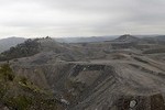
More on coal ash dams: Another one in W.Va.
June 30, 2009 by Ken Ward Jr.

An alert Coal Tattoo reader pointed out this morning that another of the coal-ash impoundments on EPA’s previously secret list of 44 high-hazard facilities reaches into West Virginia.
The Little Blue Dam near Hookstown, Pa., is in Pennsylvania, but the associated lake actually crosses the border into West Virginia. See the Google Earth map above, or click here to see a regular Google Map. My alert reader points out:
The lake is really as blue as it looks on the satellite image, even on cloudy days. Some of the lake has dried out recently, leaving behind the white gypsum and other contaminants from the fly ash.
My pal Don Hopey at the Pittsburgh Post-Gazette has written about this facility before, citing a report by the Environmental Integrity Project:
FirstEnergy’s Little Blue Run coal ash reservoir in Beaver County is the biggest in the East and one of the worst in the nation, according to an environmental group’s new pollution study.
Elsewhere on the Web, my friend Bill Kovarik, a Radford University professor and journalist, has posted a map of the general locations (not the exact coordinates) of all 44 sites on the EPA list. And another Society of Environmental Journalist buddy, Joseph Davis, has put together this list that includes photos.
For Coal Tattoo readers in West Virginia, I had previously mapped all of our state’s coal-ash impoundments, including those on today’s list. Click here for the story and the map.
As I mentioned yesterday:
It’s important to note that this “high hazard†ranking is defined this way by the U.S. Army Corps of Engineers:
Dams assigned the high hazard potential classification are those where failure or misoperation will probably cause loss of human life.Â
As EPA explained in a news release:
The rating is not an indication of the structural integrity of the unit or the possibility that a failure will occur in the future; it merely allows dam safety and other officials to determine where significant damage or loss of life may occur if there is a structural failure of the unit.Â
What does all of this mean? Here’s what Lisa Evans, a coal-ash expert with EarthJustice, said yesterday about EPA’s release of the 44-site list:
“We asked and have now received this important information about the location of some of the most dangerous and toxic coal ash sites in the U.S. This is critical information for the communities that live near these facilities who now know there is a substantial threat nearby. The next step is for EPA to regulate coal ash as hazardous waste and guarantee protections for these local communities.
“On June 18, Earthjustice, the Sierra Club, the Environmental Integrity Project and the Natural Resources Defense Council filed a Freedom of Information Act request to make public the location of these sites after the EPA refused to do so pursuant to the direction of the Department of Homeland Security since the sites pose such a threat to nearby communities that they have been deemed to be a national security risk. But the nature and location of these coal ash dump sites are precisely what the public needs to know.
“We are pleased to see that our request was not ignored and are heartened by this decision. Coal ash dump sites contain harmful levels of arsenic, lead, mercury and other toxins that can contaminate drinking water sources or potentially flood surrounding communities, as happened last December in Tennessee.
“This administration is fulfilling its commitment to scientific integrity and open government, and we hope that additional information about the location, size and ownership of the hundreds of other toxic coal ash sites will be made equally available as soon as possible. We also hope the EPA continues on this path and proposes to finally regulate toxic coal ash and once and for all establish the protections that communities and nearby neighbors want, need and deserve.â€