 Subscribe to the Coal Tattoo
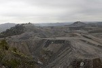
Maps, markers and Marsh Fork Elementary School
April 8, 2009 by Ken Ward Jr.

Photo courtesy of Coal River Mountain Watch
The nearly four-year fight over Massey Energy’s insistence on building new coal silos adjacent to a Raleigh County, W.Va., elementary school hit the state Supreme Court today. And the key question — legally at least — is pretty clear:
Maps or markers?
Joe Lovett, lawyer for Coal River Mountain Watch, wants the justices to rule that the permit area of a surface mine is outlined on the maps that mine operators submit to the state Department of Environmental Protection.
Doing so, Lovett told the court, would clearly put the second of two (and probably the first, truth be told) silos Massey wants at the site outside the permit boundary spelled out in 1982 mine maps. That, in turn, would invoke a federal and state law that prohibits all mining activities within 300 feet of a school.
Massey Energy subsidiary Goals Coal lawyer Bob McLusky — with a little help from DEP lawyer A.M. Pollack — asked the court to rule that on-the-ground markers, not the official maps, are the real boundaries of surface mining permits.
If the the court rules that way, then both of Massey’s silos would be just fine.
So, as Lovett pointed out to the court, maybe this is the real question that the justices should ask themselves:Â Should Goals Coal be permitted to conduct surface mining operations within 300 feet of an elementary school?
Just for fun, here’s the section of West Virginia’s mining law that justices are being asked to interpret:
“‘Permit area’ means the area of land indicated on the approved proposal map submitted by the operator as part of the operator’s application showing the location of perimeter markers and monuments and shall be readily identifiable by appropriate markers on the site.”
That’s W.Va. Code 22-3-3(q).
One of the two silos is already built, having been constructed before the Gazette and some citizens actually looked at the maps DEP was using to approve the permits.  Once DEP was confronted with the maps, agency officials initially revoked the permit. But they’ve since backed off, oddly enough, after Gov. Joe Manchin settled a civil rights lawsuit filed against him by Massey President Don Blankenship.
You can read the legal briefs in the Supreme Court case here, and we’ll have more coverage in tomorrow’s Gazette.
For the record, Chief Justice Brent Benjamin recused himself from the case. Marion County Circuit Judge Fred Fox took his place.
Not for nothing, but this case doesn’t really get to the issue that has many coalfield citizens most concerned about Marsh Fork — the huge slurry impoundment that looms over the school.
