 Subscribe to the Coal Tattoo
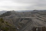
New map project highlights mountaintop removal
April 28, 2015 by Ken Ward Jr.

There’s a new mapping project out today from Appalachian Voices, SkyTruth and Google:
A new interactive map released today shows that mountaintop removal coal mining has been expanding closer to communities in Central Appalachia in recent years, posing increasing threats to human health and the environment even as coal production in the region has declined dramatically. The mapping tool, developed by the nonprofit organization Appalachian Voices, is the first-ever, time-lapse view of the proximity of mountaintop removal mines to communities.
The organization identified 50 Appalachian communities that are most at risk from destructive mining based on the proximity of mining to those communities and the rate at which mining activity has been increasing. Krypton, Ky., Bishop, W.Va., and Roaring Fork, Va. are the top three communities at risk, while the top three counties with the highest number of communities at risk are Pike County, Ky. (seven), Wise County, Va. (six), and Boone County, W.Va. (five).
Read more about it here.