 Subscribe to the Coal Tattoo
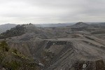
Update on Blair Mountain mining activities
February 14, 2012 by Ken Ward Jr.

In the absence of any additional information — any information, actually — from the folks at Arch Coal, I thought I would pass along a report just in from Brandon Nida at the Friends of Blair Mountain. Here it is:
Developments at Blair Mountain (Feb. 13 2012)
This report is a write-up of the most current observations. It concentrates on only two permits. It does not cover the Camp Branch permit owned by Alpha Natural Resources. It is important to realize there is a distinction between the National Register Battlefield Boundaries (NRBB) [See here for copies of maps], and the actual battlefield area. The NRBB is an arbitrary line that initially encompassed 20,000 acres, then 3200 acres, and now has been scaled back to 1600 acres. It excludes many of the property owners in Blair, and does not fully encompass the areas where combatants maneuvered. In reality, the Camp Branch, Left Fork, and Bumbo No. 2 permits are operating at different stages and irrevocably impacting the Blair Mountain battlefield.
Left Fork (S508187):
At the Left Fork surface mine permit, Arch Coal has completely cleared and begun blasting and coal removal on the 50.3 acre addition that was granted in May 2011. This area is directly adjacent to and within the viewshed of the National Register boundary. This permit addition was strongly protested by the WV State Historic Preservation officer, the letter of which can be seen at this link. Even against this strong objection, the DEP approved this permit without mitigating or researching the archaeological resources.
This area has not had thorough archaeological work performed, and so any information about the role this section played in the overall battle dynamics is lost. Both historical and limited archaeological work indicate that the Left Fork vector was a major vector of miner movement, and firefights occurred on the battle line along the section of the ridge leading to the Left Fork.
Bumbo No. 2 (S504991)
Upon investigation, Arch Coal is currently conducting blasting operations on the Bumbo #2 permit, and preparation work for further blasting has been clearly seen. There is currently no evidence that coal extraction is beginning on Bumbo #2. The current blasting would not be a logical beginning to large scale activity. The overall mining plan calls for operations to begin near the mouth of Wolfpen Branch on the north side of Bumbo #2 permit. No evidence of activity was seen in that area. But, it seems this highwall reclamation is one step in the process for operations to be able to begin.
The blasting is occurring on a knob directly west of an unreclaimed highwall and pit area that was mined under permits S501188 and S500591. The knob is between Isom Branch of Hewitt Creek and Wolfpen Branch of Beech Creek. The unreclaimed area was added to Bumbo #2 in order to use spoil from Bumbo #2 to finish reclaiming S501188. We believe Arch is blasting the top of the ridge to create spoil to complete reclamation in the area.
Both the unreclaimed area (previously worked areas) and the current blasting are on the Designated Battlefield in the northeastern extent of the ridge. The new area being blasted has not been previously surface mined, and archaeological work has been very scant. In other words, Arch Coal is blasting within the National Register Battlefield Boundary, although they are not seemingly mining coal at this stage.