 Subscribe to the Coal Tattoo
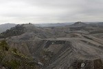
New study confirms long-term water quality damage from mountaintop removal coal mining
December 12, 2011 by Ken Ward Jr.

Photo of Hobet 21 mountaintop removal mining complex, by Vivian Stockman, Ohio Valley Environmental Coalition
A major new study out today in one of the most respected scientific journals around confirms the pervasive and irreversible impacts of mountaintop removal coal mining here in Appalachia. The study is called Cumulative impacts of mountaintop mining on an Appalachian watershed, and it appears online today in the Early Edition of the Proceedings of the National Academy of Sciences.
The conclusion by Duke University researcher Ty Lindberg and colleagues, including Emily Bernhardt:
Our results demonstrate the cumulative impact of multiple mines within a single catchment and provide evidence that mines reclaimed nearly two decades ago continue to contribute significantly to water quality degradation within this watershed.
As explained in a Duke news release:
To assess the cumulative impact of the more than 100 permitted discharge outlets draining approximately 28 square kilometers of active and reclaimed mountaintop coal mines in the Upper Mud watershed, the Duke researchers collected 152 sets of samples from 23 sites – including two sites upstream of any active or reclaimed surface mines – between May and December 2010. They sampled for electrical conductivity, a measure of salinity and for concentrations of major ions and trace elements derived from coal or its matrix rock.
The Upper Mud flows through sparsely populated sections of Boone and Lincoln counties in southern West Virginia as a headwater stream until reaching its impoundment in the Mud River reservoir 25 kilometers downstream. For about 10 kilometers, the river passes through the Hobet 21 surface mining complex, which has been active since the 1970s and is among the largest in the Appalachian coalfields region.
Here’s a figure they used in the paper:

Map of study area depicting Upper Mud River and associated tributaries with aerial photo on right. Sampling sites consisted of 15 mainstem (circles)
and eight named tributary locations (triangles). Sites 1 and 2 were located upstream of current and historic MTM activity. The remaining sites were chosen so as to bracket each confluence of the Upper Mud River and an MTM-affected tributary. Marker color denotes median conductivity level in mainstem during survey (green <300, orange 301 to 500, red 501 to 1,000, and dark red >1;000 μS cm−1). Brown shaded areas reflect surface mining with darker area representing reclaimed mines. Aerial photo on right shows location of 105 active surface-mining-related outlets within the watershed that are regulated through eight NPDES permits. Inset of US mid-Atlantic states shows Appalachian coalfield region as gray shaded area with relative location of study site in red (not to scale).
2 of
Their findings:
All conductivity measurements taken downstream of mine discharge outlets exceeded levels known to be harmful to aquatic life, said Richard Di Giulio, professor of environmental toxicology. At the two sampling sites upstream of any mines, conductivity levels were within an acceptable range. Concentrations of selenium, a known fish toxin, followed a similar trend, Di Giulio said. The researchers also observed deformities typical of selenium exposure in fish collected from downstream waters.
Co-author Avner Vengosh, professor of geochemistry and water quality, said:
As eight separate mining-impacted tributaries flowed into the Upper Mud, conductivity and concentrations of selenium, sulfate, magnesium and other inorganic solutes increased proportionately. Nearly 90 percent of the variation in trace elements and salinity could be explained by the amount of upstream surface mining.
According to the news release:
The Duke team selected the Upper Mud watershed for their field survey because water-quality impacts from other potential sources are largely absent. Historically, surface rather than underground mining has been the dominant form of coal extraction in the Upper Mud’s river basin, and there are very few people now living within the Hobet mine’s permitted boundary. This helped to minimize other factors that might account for changes in water quality.
Emily Bernhardt, associate professor of biogeochemistry, said:
This is a remarkably clean dataset and that’s why it’s so powerful. We see these incredibly strong patterns, which previously have not been well established.
Past studies have shown that individual mines profoundly impact stream water quality, biological community structure and ecosystem function immediately downstream of valley fills, but empirical data on the cumulative impacts of multiple mining operations on larger downstream rivers has been lacking, she said, adding:
Individual permitting decisions are typically made without consideration of the extent of historic mining impacts already occurring within a watershed. Our survey helps fill that gap.