 Subscribe to the Coal Tattoo
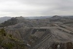
The Pine Creek Mine: Did EPA do all it could do?
October 22, 2010 by Ken Ward Jr.

The Pine Creek No. 1 Surface Mine in Logan County would cover 760 acres, or about 1.2 square miles — the equivalent of 575 football fields.
Coal industry readers of this blog might find it hard to believe, but folks in the environmental community aren’t always especially happy with what I write.
For example, I’ve heard from more than one person about this week’s two posts, “Wondering about the Spruce Mine” and “What about the alternatives?“
The general beef is that environmentalists aren’t especially happy with the U.S. Environmental Protection Agency’s approval of several key mountaintop removal permits, including Hobet 45 and the Pine Creek No.1 Surface Mine, and don’t want EPA to also cut a deal that would get the Spruce Mine OK’d.
In fact, there’s no question that most — heck, probably all — environmental groups want to see mountaintop removal abolished or banned. Activists want to see legislation passed to do this, or they want EPA to reinstate the old “fill rule” language that would block most valley fills.
And while coalfield political leaders and industry folks insist that the Obama administration is undertaking a “war on coal,” the environmental community is just as convinced that the current leadership in Washington is not doing nearly enough about the vast damage being done by mountaintop removal.
Case in point: EPA’s decision earlier this year to allow Arch Coal’s Coal-Mac subsidiary to move forward with a permit for its Pine Creek No. 1 Surface Mine near Ragland in Logan County.
This is what the Sierra Club had to say about the EPA decision:
We had high hopes that the EPA’s more stringent guidance for mountaintop removal coal mining would mean protection for our communities, but apparently we were mistaken. It’s time to turn words into action and end this destructive practice.
And here’s how the Rainforest Action Network responded:
Pine Creek is the litmus test for the EPA’s new approach to mountaintop removal mining permits in Appalachia – and we can see that they are happy to see this devastating practice continue.
The massive Pine Creek Surface Mine and the neighboring communities and watershed suffer from the cumulative impacts of being surrounded by other mountaintop removal coal mines. This permit would allow Arch Coal Inc.’s Coal-Mac to dump toxic mining waste into three entire valleys.
Interestingly, the Rainforest Action Network hired the fine folks from Downstream Strategies in Morgantown to take a closer look at the Pine Creek permit and write a report about its potential impacts and whether it fits in with EPA’s stated guidelines for when such projects meet the Clean Water Act. The report by Rory McIlmoil and Anne Hereford is posted here, and I thought we would take a closer look at what it found.

Of the 455 square miles of land in Logan County, surface mining and valley fills have impacted nearly 80.8 square miles, or about 18 percent of the land area in the county, according to Downstream Strategies.
First, let’s remember what permit changes EPA said led it to sign off on approval of the Pine Creek proposal. Here’s how EPA summarized those changes in a news release:
Reduce Stream Impacts: The original mine plan proposed to have the full mine area disturbed and all three proposed valley fills under construction within 12 to 18 months of commencing operations. EPA worked with the company to reduce stream impacts significantly.
Protect Water Quality: EPA worked with the Corps and company to ensure mining related conductivity (a measure of salinity) remains at levels that will not cause or contribute to degradation to water quality or streamlife. Extensive chemical and biological stream monitoring is required to demonstrate that conductivity remains below acceptable levels, set in the EPA guidance, before the Corps and EPA will approve additional mining. If this condition is not achieved, Coal-Mac is not authorized to proceed with the construction of the next valley fill.
Sequencing Valley Fill: EPA reached an agreement to sequence valley fill construction so that no new mining is approved by the Corps and EPA unless it is demonstrated that water quality standards are being met and public health is being protected.
Enhance Mitigation: Coal-Mac proposed on-site stream restoration and creation of 40,000-plus linear feet of stream. The plan includes a significant monitoring plan and benchmarks for success, an adaptive management plan that provides back up plans if the projects are unsuccessful. It also includes upfront financial assurances. The applicant’s benchmarks of success include biological, chemical and physical measures that are intended to replace the lost functions within the immediate watershed. EPA believes the proposed mitigation is consistent with Clean Water Act regulations.
Avoid Cumulative Impacts: To address cumulative impacts, Coal-Mac has offered to deed-restrict three areas previously permitted to be filled on the Phoenix No. 5 Surface Mine operation, where five valley fills were authorized. Two valley fills have been constructed and Coal-Mac will deed-restrict the three-remaining unfilled sites. Those areas will not be subject to filling now or in the future. This is an avoidance of impacts to 3,900 linear feet of stream channel.
But here’s what Downstream Strategies had to say about those issues and this mine that EPA approved:
— First, there’s no guarantee that the second two valley fills on the Left Fork of Pine Creek won’t be constructed. If the first fill meets EPA’s conductivity guideline, the company can move ahead with the others. According to Downstream strategies:
… Then, Coal-Mac would be able to proceed with construction of the second valley fills, thereby increasing the potential impact on streams in the Left Fork. Additionally, the impact on 14,530 linear feet of stream channel is likely to reduce the available load capacity of the local stream system. In other words, there will be nearly three miles of streams, and therefore, three miles of channels lost for transporting rainwater runoff from the mine site and valley fills. This could have severe implications for flooding potential in downstream communities.
— Next, how about this idea that Coal-Mac has agreed to deed restrictions that would prevent three proposed valley fills from ever being built on the company’s nearby Phoenix No. 5 Surface Mine? EPA says this will avoid impacts to 3,900 feet (nearly three-quarters of a mile) of stream channel “a 39.5 percent reduction of impacts within the Pine Creek watershed.” Well, as Downstream Strategies points out:
… Through this statement, EPA is ignoring the fact that the net impact of streams in the Pine Creek watershed would [still] be a positive, rather than a net reduction.
Should the mining proceed, the total direct impact to streams within the Pine Creek watershed will total approximately 4.1 miles. Total length of stream in the sub-watershed … amounts to 11.2 miles. Therefore, according to our GIS analysis, the proportion of streams in the Pine Creek stream system impacted by surface mining will increase from 17 percent to 37 percent, more than doubling the total direct impact to the watershed.
— Also, Downstream Strategies argues that EPA wrongly did not examine the cumulative impacts over a broader area:
… Approximately 150 total miles of streams in Logan County have been directly impacted by surface mining, out of a total of 976 miles of streams within the county. Therefore, according to a basic analysis of the GIS data, approximately 15 percent of streams in the county have been mined through or filled as a result of surface mining activities.
— More to the point, regarding whether this specific Pine Creek Mine permit complies with EPA’s own new conductivity guidelines, Downstream Strategies reported that EPA’s approval of the permit:
… Makes no mention of baseline conductivity levels in either the Right or Left Fork of Pine Creek. The only mention of existing conductivity levels are those measured in the streams below the three proposed valley fills associated with the Phoenix No. 5 permit that are being deed restricted for the purpose of mitigating the stream impacts from the Pine Creek permit.
… Finally, and perhaps more importantly, the USEPA letter does not provide the public any indication that USEPA, in order to protect against cumulative impacts to watersheds, has required Coal-Mac to submit data and water quality and discharges from all “adjacent or similar projects” or their associated SMCRA and Section 404 permits. This is significant given the scale of existing impacts to the Pine Creek and other surrounding watersheds from past mining, most of which has been conducted by Coal-Mac.
— In addition, Downstream Strategies notes that EPA has said that mining companies “must avoid and minimize their direct, indirect and cumulative adverse environmental impacts to streams, wetlands, watersheds and other aquatic resources.” But, Downstream Strategies says:
… The elimination of three valley fills — that have yet to be constructed — while still approving one, and potentially two or three new valley fills and their associated sediment ponds, does not achieve the stated intent of this guideline.
There are still existing impacts from multiple valley fills that have been previously constructed in the Pine Creek watershed, and any new valley fills will add to those impacts. Additionally, there is no mention of the potential indirect impacts that are likely to occur downstream of the surface mine.
In essence, USEPA by falsely claiming a reduction in cumulative impacts, is ignoring or distracting from the fact that the net impact to streams in the Pine Creek watershed from the Pine Creek surface mine will still be positive, not negative. Once the Pine Creek mining operation is completed, the net cumulative impact to streams in the watershed will exceed the impacts that existed before the mining occurred.