 Subscribe to the Coal Tattoo
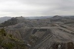
Mountaintop removal: Then and now
March 2, 2010 by Ken Ward Jr.
Then:

And now:

The good folks at NASA’s Earth Observatory Web site just posted tomorrow’s “Image of the Day,” and it’s an interesting look at the Growth of Mountaintop Removal in West Virginia.
The site features two satellite photos of the Hobet 21 mining complex along the Boone-Lincoln County line south of Charleston, one from 1984 (top) and one from last summer (bottom).
Earth Observatory explained:
Based on data from NASA’s Landsat 5 satellite, these natural-color (photo-like) images document the growth of the Hobet mine in Boone County, West Virginia, as it expands from ridge to ridge between 1984 to 2009. The natural landscape of the area is dark green, forested mountains, creased by streams and indented by hollows. The active mining areas appear off-white, while areas being reclaimed with vegetation appear light green. A pipeline roughly bisects the images from north to south.
Earth Observatory previously covered the mountaintop removal issue with a feature called Coal Controversy in Appalachia, available here. Please visit their site to get a bigger and better look at the photos I’ve posted above.
And be sure to click here to watch a photo show of how the Hobet 21 images have changed over time.