 Subscribe to the Coal Tattoo
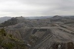
Marsh Fork kids: What kind of justice is Menis?
June 10, 2009 by Ken Ward Jr.

Menis Ketchum, left, is sworn in as a West Virginia Supreme Court Justice by Judge Michael Thornsbury, right, as his wife Judy Ketchum holds the Bible in the West Virginia Supreme Court chambers at the state capitol in Charleston, W.Va., Thursday, Dec. 18, 2008. AP Photo.
Reactions are still coming in from around the country to yesterday’s West Virginia Supreme Court ruling to allow Massey Energy to continue its plans to expand the coal-processing facility it operates adjacent to Marsh Fork Elementary School in Raleigh County.
One Coal Tattoo reader asked me in an e-mail message if I thought the justices had ever heard of Aberfan, the Welsh town where 144 people — including 116 children –Â died in 1966 (six years before the Buffalo Creek disaster) when a coal waste impoundment failed. (Some local folks had raised concerns three years earlier about the slag being piled above the village elementary school — but they were ignored).
On Grist, the always soft-spoken Jeff Biggers wrote:
The Marsh Fork Elementary School might be the poster child for everything that is wrong about our failed mining policies: Only a few football fields downslope of a 2.8 billion gallon coal sludge impoundment, the school and its children are also subjected to the toxic coal dust within a football field of their playground.
My question now is a little bit different, though very related: What does this ruling tell us about Menis Ketchum, the new state Supreme Court Justice who wrote it for the unanimous court?
Well, it was clear that Ketchum went to great lengths to distance his ruling from any of the controversy over the silo, let alone the coal-slurry impoundment up the hollow:
This case involves the interpretation of several statutes. The sterile, narrow legal question presented by CRMW’s appeal is simple: under the West Virginia Surface Coal Mining and Reclamation Act and the federal Surface Mining Control and Reclamation Act, is the “permit area†of a surface mine operation defined solely by the maps submitted with the original permit application? Or may the permit area be defined by reference to the maps and markers buried or installed on the mining site?
 This case does not involve the public policy effects of these Acts. We are aware of the extensive public concern about appellee Goals Coal’s decision to construct a second coal silo less than a football field’s length from an elementary school. The DEP has determined it must allow the construction to occur in deference to statutory law. The wisdom or desirability of these decisions are outside the province of the judicial branch.
OK, fine. So what Justice Ketchum says is that his job is just to read the law and tell us what it says. And in this case, Ketchum wrote that the definition of “permit area” for a strip mine is so clear that it speaks for itself. That definition? It says that permit area is:
“… The area of land indicated on the approved proposal map submitted by the operator as part of the operator’s application showing the location of perimeter markers and monuments and shall be readily identifiable by appropriate markers on the site.â€
I’ve highlighted the portion that lawyers for Coal River Mountain Watch urged the Supreme Court to pay attention to — the part that says the permit area is that boundary shown on the map, and the part, if enforced, that would kill Massey’s plan for this new coal silo. Massey and the Manchin administration’s Department of Environmental Protection argued that the other part of the definition was what mattered — that is, the part that says the true permit boundary is what the markers on the ground show (markers that, in this case, would clear the way for the silo).
Not for nothing, check out the federal strip mining law’s definition of permit area:
“… The area of land indicated on the approved map submitted by the operator with his application, which area of land . . . shall be readily identifiable by appropriate markers on the site[.]”
Coal River Mountain Watch argued that the comma after the word “appplication,” followed by the pronoun “which,” set everything off after the comma as a “nonrestrictive clause” that simply explained that the on-the-ground markers must reflect what was shown on the map.
As I’ve written before, this dispute — maps vs. markers — was the legal issue at the heart of this case.
What Ketchum and the court did was read the statute, and then stop. In effect, they took a legal path through which they said the law was so clear there was no need for them as a court to do any interpreting:
After carefully examining the parties’ arguments, we conclude that the statutes at issue are clear and without ambiguity. “Where the language of a statute is clear and without ambiguity the plain meaning is to be accepted without resorting to the rules of interpretation.”
This is the equivalent of the justices saying their hands are tied — As sympathetic as they might (or might not) be to the citizen group’s case, they could be saying, there’s just nothing they can do about it.
But buried in a footnote in the case is clear evidence that the court didn’t really stop there … it did do some interpreting here.
Check out Footnote 6, where Ketchum explains why the maps can’t really be the legal permit boundary:
This conclusion is compelled by the fact that Congress expressed a preference that permit application maps be drawn on a scale of 1:24,000 or 1:25,000. 30 U.S.C. § 1257(b)(13)(B). At the smaller of these scales, 1:24,000, 1 inch is the equivalent of 500 feet. At this scale, the thickness of a pen stroke of 1/20th of an inch identifying a boundary line would represent 25 feet on the ground.
What’s that all about? Well, despite his protestations otherwise, Ketchum has in fact looked beyond the specific statutory definition of permit area, to a different section of strip mining law that he says bolsters his conclusion. And he’s done more than that. The good justice has also — drawing interestingly enough from Massey lawyer Bob McLusky’s brief, without saying so — gone beyond just reading the statute to interpreting it, by saying that the markers must be the permit boundary because making the maps the boundary would be impractical for the industry and WVDEP.
Further, Ketchum didn’t even accurately quote the federal law he cited in his footnote. He left out the part where Congress said maps of different scaled could be used if needed for clarity. The entire section states that operators must submit permit applications on:
…Accurate maps to an appropriate scale clearly showing (A) the land to be affected as of the date of application and (B) all types of information set forth on topographical maps of the United States Geological Survey of a scale of 1:24,000 or 1:25,000 or larger, including all manmade features and significant known archeological sites existing on the date of application. Such a map or plan shall among other things specified by the regulatory authority show all boundaries of the land to be affected, the boundary lines and names of present owners of record of all surface areas abutting the permit area, and the location of all buildings within one thousand feet of the permit area…
So if coal operators thought the 1:24,000 or 1:25,000 scale maps were not accurate to show permit boundaries, they were free to use something else. McLusky inadvertently made this very point in his brief, by citing the state regulations that were in effect at the time the original permit application was filed for the Marsh Fork mine site, requiring that:
…The scale for all maps, unless otherwise noted, was to be a USGS 7.5-minute quadrangle map enlarged to 500 feet or less to the inch, though lesser scales could be used for improved clarity…
This all reminds me of one of the first stories I did about Marsh Fork Elementary, back in the summer of 2005, when a grandfather named Ed Wiley went and sat on the Capitol steps here in Charleston, saying he wouldn’t leave until Gov. Joe Manchin agreed to meet with him about the school’s location. The governor agreed to meet with Wiley, and then ordered his top staffers to take a closer look at the situation.
We now know that the WVDEP and Manchin backed off any real inquiry into the safety of the school, oddly enough not long after Manchin settled a civil rights lawsuit filed against him by Massey President Don Blankenship.
But that day when he met with Wiley, the governor came back out to the Capitol steps and had a press conference with Wiley. Everybody was asking questions about their meeting.
I asked the governor something more basic: Would he want his grandchildren attending Marsh Fork Elementary? Manchin responded:
 I don’t know enough. I haven’t been there. I don’t know enough about the site.
By the way, here’s a fairly recent photo of the site, taken by Vivian Stockman of the Ohio Valley Environmental Coalition. That’s the school, all the way down in the right-hand corner.
